The Saffir-Simpson Hurricane Wind Scale
National Weather Service Tropical Cyclone Wind Scale


Venice
Get to know our slice of Paradise - located on the SW Coast of Fl.
Attractions
Beaches
Canoe/Kayak
Boat Launches
Boat Charters
Fishing Charter
Fishing Piers
Historical Sites
Golf
Parks
Hotels
Relocate
Venice Map
Weather Links
About Tropical Cyclones
NHC/NOAA
Puerto Rico Radar
Atlantic Tropical Storm 1
Atlantic Tropical Storm 2
Eastern Pacific Storm 1
Eastern Pacific Storm 2
The Cooperative Institute for Meteorological Satellite Studies (CIMMS)
Tropical Cyclone
website offers up-to-date worldwide tracking of tropical cyclones.
Peak of Season Map
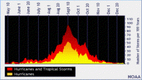
Peak tropical storm season is around September 10th
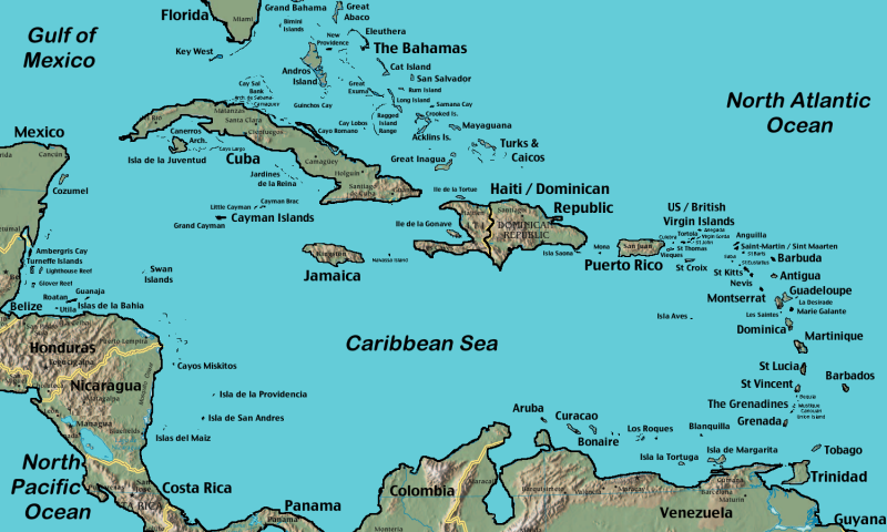
Caribbean Map
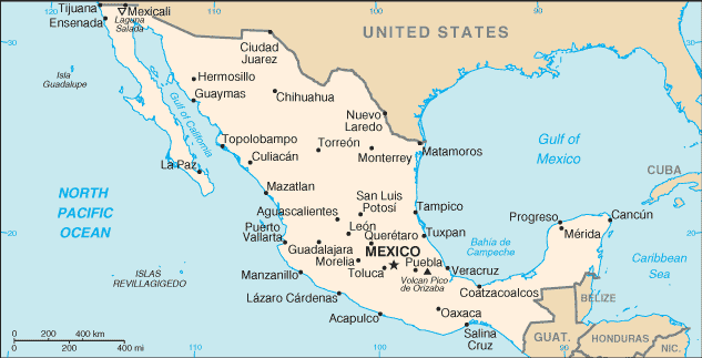
Mexico Map
ports > weather > Wind Scale
Wind Scale

The Saffir-Simpson Hurricane Wind Scale is a 1 to 5 categorization based on the hurricane's intensity at the indicated time. The scale provides examples of the type of damages and impacts in the United States associated with winds of the indicated intensity.
| CAT 1 | CAT 3 | CAT 5 |
| CAT 2 | CAT 4 |
Tropical Depression
Wind speed less than 39 MPH
Tropical Storm
Wind speed between 39 MPH and 73 MPH
Category One Hurricane:
Sustained winds 74-95 mph (64-82 kt. or 119-153 km/hr.). Damaging winds are expected. Some damage to building structures could occur, primarily to unanchored mobile homes (mainly pre-1994 construction). Some damage is likely to poorly constructed signs. Loose outdoor items will become projectiles, causing additional damage. Persons struck by windborne debris risk injury and possible death. Numerous large branches of healthy trees will snap. Some trees will be uprooted, especially where the ground is saturated. Many areas will experience power outages with some downed power poles.
● Hurricane Cindy (pdf) (2005, 75 mph winds at landfall in Louisiana) and Hurricane Gaston (2004, 75 mph winds at landfall in South Carolina) are examples of Category One (1) hurricanes.
Category Two Hurricane:
Sustained winds 96-110 mph (83-95 kt. or 154-177 km/hr.) Very strong winds will produce widespread damage. Some roofing material, door, and window damage of buildings will occur. Considerable damage to mobile homes (mainly pre-1994 construction) and poorly constructed signs is likely. A number of glass windows in high rise buildings will be dislodged and become airborne. Loose outdoor items will become projectiles, causing additional damage. Persons struck by windborne debris risk injury and possible death. Numerous large branches will break. Many trees will be uprooted or snapped. Extensive damage to power lines and poles will likely result in widespread power outages that could last a few to several days.
● Hurricane Erin (1995, 100 mph at landfall in northwest Florida) and Hurricane Isabel (2003, 105 mph at landfall in North Carolina) are examples of Category Two (2) hurricanes.
Category Three Hurricane:
Sustained winds 111-129 mph (96-112 kt., 178-208 km/h). Dangerous winds will cause extensive damage. Some structural damage to houses and buildings will occur with a minor amount of wall failures. Mobile homes (mainly pre-1994 construction) and poorly constructed signs are destroyed. Many windows in high rise buildings will be dislodged and become airborne. Persons struck by windborne debris risk injury and possible death. Many trees will be snapped or uprooted and block numerous roads. Near total power loss is expected with outages that could last from several days to weeks.
● Hurricane Rita (pdf) (2005, 115 mph landfall in east Texas/Louisiana); Hurricane Katrina (2005, 125 mph winds; and Hurricane Jeanne (2004, 120 mph landfall in southeast Florida) are examples of Category Three (3) hurricanes.
Category Four Hurricane:
Sustained winds 130-156 mph (113-136 kt., or 209-251 km/h). Extremely dangerous winds causing devastating damage are expected. Some wall failures with some complete roof structure failures on houses will occur. All signs are blown down. Complete destruction of mobile homes (primarily pre-1994 construction). Extensive damage to doors and windows is likely. Numerous windows in high rise buildings will be dislodged and become airborne. Windborne debris will cause extensive damage and persons struck by the wind-blown debris will be injured or killed. Most trees will be snapped or uprooted. Fallen trees could cut off residential areas for days to weeks. Electricity will be unavailable for weeks after the hurricane passes.
● Hurricane Charley (2004, 145 mph at landfall in southwest Florida) and Hurricane Hugo (1989, 140 mph at landfall in South Carolina) are examples of Category Four (4) hurricanes.
Category Five Hurricane:
Sustained winds greater than 156 mph (137 kt. or 252 km/hr.) Catastrophic damage is expected. Complete roof failure on many residences and industrial buildings will occur. Some complete building failures with small buildings blown over or away are likely. All signs blown down. Complete destruction of mobile homes (built in any year). Severe and extensive window and door damage will occur. Nearly all windows in high rise buildings will be dislodged and become airborne. Severe injury or death is likely for persons struck by wind-blown debris. Nearly all trees will be snapped or uprooted and power poles downed. Fallen trees and power poles will isolate residential areas. Power outages will last for weeks to possibly months.
● Hurricane Camille (pdf) (1969, 190 mph at landfall in Mississippi) and Hurricane Andrew (1992, 165 mph at landfall in Southeast Florida) are examples of Category Five (5) hurricanes.
Source: NWS